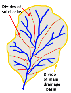
A drainage basin is the area within the drainage basin divide (yellow outline), and drains the surface runoff and river discharge (blue lines) of a contiguous area.
A drainage basin is a region of land where water from rain or snowmelt drains downhill into a body of water, such as a river, lake, dam, estuary, wetland, sea or ocean. The drainage basin includes both the streams and rivers that convey the water as well as the land surfaces from which water drains into those channels. The drainage basin acts like a funnel - collecting all the water within the area covered by the basin and channeling it into a waterway. Each drainage basin is separated topographically from adjacent basins by a ridge, hill or mountain, which is known as a water divide or a watershed. Especially in North American usage however, watershed refers to the drainage basin itself. Other terms that can be used to describe the same concept are catchment, catchment area, catchment basin, drainage area, river basin and water basin. There are two different patterns in which water can drain. The first one is called a dendritic drainage pattern. The second drainage pattern is called a trellis drainage pattern.
Ocean drainage basins[]
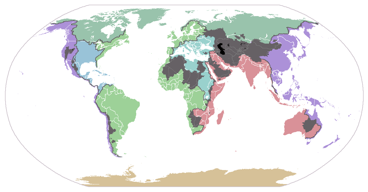
Drainage basins of the major oceans and seas of the world. Grey areas are endorheic basins that do not drain to the ocean.
- The Atlantic Ocean drains approximately 47% of all land in the world. In North America, it directly drains the Saint Lawrence River and Great Lakes basins, the Eastern Seaboard of the United States, the Canadian Maritimes, and Newfoundland and Labrador. It also directly drains nearly all of South America (that portion east of the Andes), northern Europe, and the greatest portion of western Sub-Saharan Africa. The the three major mediterranean seas of the world also flow to the Atlantic:
- The basin of the American Mediterranean Sea (the Caribbean Sea and Gulf of Mexico) includes all of the American interior between the Appalachian and Rocky mountains, eastern Central America, and a small part of northern South America.
- The basin of the European Mediterranean Sea includes much of northeastern Africa (including Egypt, Libya, Sudan and the other countries of the Nile basin), southern and eastern Europe, Turkey, and the coastal areas of Israel, Lebanon, and Syria.
- The basin of the Arctic Sea drains most of northern Canada and Russia.
- The Pacific Ocean drains just over 13% of the land in the world. Its basin includes much of China, southeastern Russia, Japan, Korea, most of Indonesia and Malaysia, the Philippines, all Pacific Islands, the northeast coast of Australia, most of Alaska, the western part of Canada, the United States, Central America, and the South America (the smaller portion west of the Andes).
- The Indian Ocean drains around 13% of the Earth's land. It drains the eastern coast of Africa, the coasts of the Red Sea and the Persian Gulf, the Indian subcontinent, Burma, and most of Australia.
- The Southern Ocean drains Antarctica. (At least those portions that drain; there is no runoff from the interior of the continent.) Antarctica comprises approximately 8% of the Earth's land.
Endorheic drainage basins[]
Endorheic drainage basins are inland basins that do not drain into an ocean; around 18% of all land drains to endorheic lakes or seas. The largest of these consists of much of the interior of Asia, and drains into the Caspian Sea and the Aral Sea. Other basins include the Great Basin in the United States, much of the Sahara Desert, the watershed of the Okavango River (Kalahari Basin), highlands near the African Great Lakes, the interiors of Australia and the Arabian Peninsula, and parts in Mexico and the Andes.
Geopolitical boundaries[]
Drainage basins have been important historically in determining boundaries, particularly in regions where trade by water has been important. For example, the English crown gave the Hudson's Bay Company a monopoly on the Indian Trade in the entire Hudson Bay watershed, an area called Rupert's Land. The company later acquired the North American watershed of the Arctic Ocean (the North-Western Territory). These lands later became part of Canada as the Northwest Territories, making up the vast majority of Canada's land area.
Today, bioregional democracy can include agreements of states in a particular drainage basin to defend it. These include the Great Lakes Commission.
Hydrology[]
Drainage basin of the Ohio River, part of the Mississippi River drainage basin.
The largest drainage basin in the world is the Amazon, covering 6,144,727 km² (a third of the area of South America).
In hydrology, the drainage basin is a logical unit of focus for studying the movement of water within the hydrological cycle, because the majority of water that discharges from the basin outlet originated as precipitation falling on the basin. A portion of the water that enters the groundwater system beneath the drainage basin may flow towards the outlet of another drainage basin because groundwater flow directions do not always match those of their overlying drainage network. Measurement of the discharge of water from a basin may be made by a stream gauge located at the basin's outlet.
Rain gauge data is used to measure total precipitation over a drainage basin, and there are different ways to interpret that data. If the gauges are many and evenly distributed over an area of uniform precipitation, using the arithmetic mean method will give good results. In the Thiessen polygon method, the watershed is divided into polygons with the rain gauge in the middle of each polygon assumed to be representative for the rainfall on the area of land included in its polygon. These polygons are made by drawing lines between gauges, then making perpendicular bisectors of those lines form the polygons. The isohyetal method involves contours of equal precipitation are drawn over the gauges on a map. Calculating the area between these curves and adding up the volume of water is time consuming.
Ecology[]
The Mississippi River drains the largest area of any U.S. river, much of it agricultural regions. Agricultural runoff and other water pollution that flows to the outlet is the cause of the dead zone in the Gulf of Mexico.
Drainage basins are important elements to consider also in ecology. As water flows over the ground and along rivers it can pick up nutrients, sediment, and pollutants. Like the water, they get transported towards the outlet of the basin, and can affect the ecological processes along the way as well as in the receiving water body.
Modern usage of artificial fertilizers, containing nitrogen, phosphorous, and potassium, has affected the mouths of watersheds. The minerals will be carried by the watershed to the mouth and accumulate there, disturbing the natural mineral balance.
Resource management[]
Because drainage basins are coherent entities in a hydrological sense, it has become common to manage water resources on the basis of individual basins. In Minnesota, U.S.A., governmental entities that perform this function are called watershed districts. In New Zealand, they are called catchment boards. Comparable community groups based in Ontario, Canada, are called conservation authorities. In North America this function is referred to as watershed management. In Brazil, the National Policy of Water Resources, regulated by Act n° 9.433 of 1997, establishes the drainage basin as territorial division of Brazilian water management.
References[]
External links[]
- A detailed map of watersheds in North America
- Science in Your Watershed, USGS
- Studying Watersheds: A Confluence of Important Ideas
- Map of the Earth's primary drainage basins/watersheds, WRI
- Surf Your Watershed, EPA
- [3]
- Cycleau - A project looking at approaches to managing catchments in North West Europe
- The Watershed Management Council - The art and science of watershed management
Original version adapted from the Wikipedia article, "Drainage basin" http://en.wikipedia.org/wiki/Drainage_basin